Geolocate

Hillside topographic map

Click on the map to display elevation.

About this map

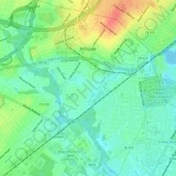
Name: Hillside topographic map, elevation, terrain.

Location: Hillside, Union County, New Jersey, 07205, United States (40.67505 -74.24934 40.71119 -74.20904)

Average elevation: 72 ft

Minimum elevation: 10 ft

Maximum elevation: 194 ft

Union County trails, hiking, mountain biking, running and outdoor activities

Other topographic maps

Click on a map to view its topography, its elevation and its terrain.

Woodland Park

United States > New Jersey > Union County > Summit

Average elevation: 361 ft

Sunnyside

United States > New Jersey > Union County > Linden

Average elevation: 56 ft

Tremley

United States > New Jersey > Union County > Linden

Average elevation: 13 ft

Woodland Park

United States > New Jersey > Union County > Summit

Average elevation: 361 ft

Tremont Park

United States > New Jersey > Union County > Summit

Average elevation: 335 ft

Gear up for your next adventure:

🔪Outdoor Multitools - Essential survival tools for gear repair and field use
🦺Reflective Outdoor Gear - Safety gear for low‑light conditions
🏥Hiking First Aid Kits - Comprehensive medical kits for remote trail injuries
🥾Hiking Shoes - Durable and comfortable shoes for trail hiking
🧴Hand Sanitizer - Keep hands clean while hiking

As an Amazon Associate, this site earns from qualifying purchases at no extra cost to you.