
Thank you for supporting this site ❤️
Make a donation
Make a donation
Gear up for your next adventure:
As an Amazon Associate, this site earns from qualifying purchases at no extra cost to you.
Wakka topographic map
Click on the map to display elevation.
Thank you for supporting this site ❤️
Make a donation
Make a donation
Gear up for your next adventure:
As an Amazon Associate, this site earns from qualifying purchases at no extra cost to you.
About this map
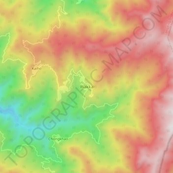
Name: Wakka topographic map, elevation, terrain.
Location: Wakka, Wakka SDO, Longding, Arunachal Pradesh, India (26.75159 95.40799 26.83159 95.48799)
Average elevation: 5,125 ft
Minimum elevation: 2,251 ft
Maximum elevation: 7,766 ft
Thank you for supporting this site ❤️
Make a donation
Make a donation
Gear up for your next adventure:
As an Amazon Associate, this site earns from qualifying purchases at no extra cost to you.