
Mica Peak topographic map
Interactive map
Click on the map to display elevation.
About this map
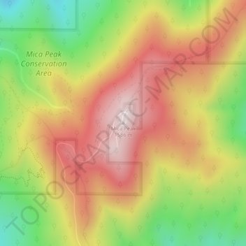
Name: Mica Peak topographic map, elevation, terrain.
Location: Mica Peak, Spokane County, Washington, United States (47.57335 -117.08174 47.57345 -117.08164)
Average elevation: 4,301 ft
Minimum elevation: 3,248 ft
Maximum elevation: 5,194 ft
Mica Peak is the name of two separate mountain summits in the United States located approximately 5.49 miles (9 km) apart; one in Spokane County, Washington and the other in Kootenai County, Idaho. The two peaks are located along the same ridge, which separates the Spokane Valley and Rathdrum Prairie from the Palouse. The mountains have an elevation difference of only 31 ft (9.4 m) and are the southernmost peaks of the Selkirk Mountains.
Other topographic maps
Click on a map to view its topography, its elevation and its terrain.
Spokane
United States > Washington > Spokane County
Spokane, Spokane County, Washington, United States
Average elevation: 2,149 ft
Spokane Valley
United States > Washington > Spokane County
Spokane Valley, Spokane County, Washington, United States
Average elevation: 2,208 ft
Hampton Bay
United States > Washington > Spokane County
Hampton Bay, Spokane County, Washington, United States
Average elevation: 2,185 ft
Nine Mile Falls
United States > Washington > Spokane County
Nine Mile Falls, Spokane County, Washington, 99026, United States
Average elevation: 1,759 ft
Otis Orchards-East Farms
United States > Washington > Spokane County
Otis Orchards-East Farms, Spokane County, Washington, United States
Average elevation: 2,192 ft
Mount Spokane State Park
United States > Washington > Spokane County
Mount Spokane State Park, Spokane County, Washington, United States
Average elevation: 3,202 ft
Country Homes
United States > Washington > Spokane County
Country Homes, Spokane County, Washington, 99251, United States
Average elevation: 1,965 ft
Mead
United States > Washington > Spokane County
Mead, Spokane County, Washington, 99021, United States
Average elevation: 1,919 ft
Mica
United States > Washington > Spokane County
Mica, Spokane County, Washington, 99023, United States
Average elevation: 2,533 ft
East Spokane
United States > Washington > Spokane County > Spokane Valley > East Spokane
East Spokane, Spokane Valley, Spokane County, Washington, 99260, United States
Average elevation: 2,051 ft
Riverfront Park
United States > Washington > Spokane County > Spokane
Riverfront Park, Spokane, Spokane County, Washington, United States
Average elevation: 1,913 ft
Beacon Hill
United States > Washington > Spokane County
Beacon Hill, Spokane County, Washington, 99211, United States
Average elevation: 2,162 ft
Orchard Prairie
United States > Washington > Spokane County
Orchard Prairie, Spokane County, Washington, United States
Average elevation: 2,238 ft