
Mead topographic map
Click on the map to display elevation.
About this map
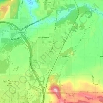
Name: Mead topographic map, elevation, terrain.
Location: Mead, Spokane County, Washington, 99021, United States (47.74739 -117.37494 47.78739 -117.33494)
Average elevation: 1,919 ft
Minimum elevation: 1,677 ft
Maximum elevation: 2,264 ft
Spokane County trails, hiking, mountain biking, running and outdoor activities
Other topographic maps
Click on a map to view its topography, its elevation and its terrain.
Riverside State Park
United States > Washington > Spokane County > Spokane
Terrain in park is varied, with steep valleys along the rivers and more flat plateaus above. The Spokane River falls from approximately 1,680 feet when it enters the park in the south to approximately 1,540 feet at the Long Lake Reservoir on the northern edge of the park. Surrounding plateaus rise to 2,200…
Average elevation: 2,116 ft
Millwood
United States > Washington > Spokane County
The topography of the city is mostly flat as it lies on the floor of the Spokane Valley, though it does slope gently down towards the north. The northern edge of town is defined by the Spokane River, where the terrain promptly drops about 20 feet down to the river bank.
Average elevation: 1,969 ft