
Thank you for supporting this site ❤️
Make a donation
Make a donation
Gear up for your next adventure:
As an Amazon Associate, this site earns from qualifying purchases at no extra cost to you.
Sabroso topographic map
Click on the map to display elevation.
Thank you for supporting this site ❤️
Make a donation
Make a donation
Gear up for your next adventure:
As an Amazon Associate, this site earns from qualifying purchases at no extra cost to you.
About this map
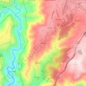
Name: Sabroso topographic map, elevation, terrain.
Location: Sabroso, Folhadela, Vila Real, 5000-103, Portugal (41.23700 -7.75473 41.27700 -7.71473)
Average elevation: 1,371 ft
Minimum elevation: 472 ft
Maximum elevation: 2,018 ft
Thank you for supporting this site ❤️
Make a donation
Make a donation
Gear up for your next adventure:
As an Amazon Associate, this site earns from qualifying purchases at no extra cost to you.