
Thank you for supporting this site ❤️
Make a donation
Make a donation
Gear up for your next adventure:
As an Amazon Associate, this site earns from qualifying purchases at no extra cost to you.
Eirexe topographic map
Click on the map to display elevation.
Thank you for supporting this site ❤️
Make a donation
Make a donation
Gear up for your next adventure:
As an Amazon Associate, this site earns from qualifying purchases at no extra cost to you.
About this map
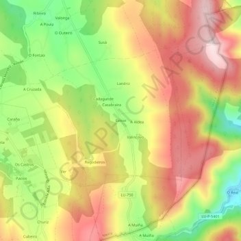
Name: Eirexe topographic map, elevation, terrain.
Location: Eirexe, Milleirós, Pol, Meira, Lugo, Galicia, 27275, España (43.11021 -7.29885 43.15021 -7.25885)
Average elevation: 2,123 ft
Minimum elevation: 1,430 ft
Maximum elevation: 2,720 ft
Thank you for supporting this site ❤️
Make a donation
Make a donation
Gear up for your next adventure:
As an Amazon Associate, this site earns from qualifying purchases at no extra cost to you.
Other topographic maps
Click on a map to view its topography, its elevation and its terrain.