Geolocate

Lappach topographic map

Click on the map to display elevation.

About this map

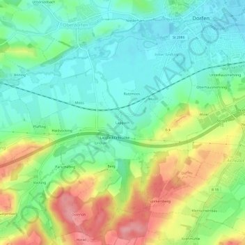
Name: Lappach topographic map, elevation, terrain.

Location: Lappach, Dorfen, Landkreis Erding, Bayern, 84405, Deutschland (48.23759 12.11381 48.27759 12.15381)

Average elevation: 1,568 ft

Minimum elevation: 1,430 ft

Maximum elevation: 1,808 ft

Gear up for your next adventure:

🥘Titanium Cookware - Durable, featherlight pots and pans for backpacking
🥾Women's Hiking Boots - Top-rated trail boots with ankle support and superior grip
🧤Hiking Gloves - Protective gloves for rugged trails
❄️Traction Cleats - Prevent slips on icy trails during winter hikes
📚Navigation Handbooks - Master the art of reading topographic maps and using a compass

As an Amazon Associate, this site earns from qualifying purchases at no extra cost to you.