
Make a donation
Gear up for your next adventure:
As an Amazon Associate, this site earns from qualifying purchases at no extra cost to you.
Pyawbwe Township topographic map
Click on the map to display elevation.
Make a donation
Gear up for your next adventure:
As an Amazon Associate, this site earns from qualifying purchases at no extra cost to you.
About this map
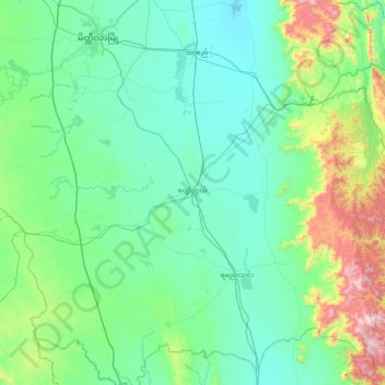
Name: Pyawbwe Township topographic map, elevation, terrain.
Location: Pyawbwe Township, Yamethin District, Mandalay, Myanmar (20.39607 95.57019 20.77557 96.34338)
Average elevation: 1,102 ft
Minimum elevation: 446 ft
Maximum elevation: 4,419 ft
Make a donation
Gear up for your next adventure:
As an Amazon Associate, this site earns from qualifying purchases at no extra cost to you.
Other topographic maps
Click on a map to view its topography, its elevation and its terrain.
Mogok
At 1,170 metres (3,840 ft) in elevation, the city has a fairly temperate climate year-round, and is home to Bamar, Shan, Lisu, Palaung, and Karen ethnic groups, as well as Chinese, Indians and Gurkhas. The city is composed of two towns, Mogok and Kyat Pyin. Mogok is four miles long and two miles wide. It is…
Average elevation: 3,258 ft