
Make a donation
Gear up for your next adventure:
As an Amazon Associate, this site earns from qualifying purchases at no extra cost to you.
Dadaab topographic map
Click on the map to display elevation.
Make a donation
Gear up for your next adventure:
As an Amazon Associate, this site earns from qualifying purchases at no extra cost to you.
About this map
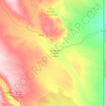
Name: Dadaab topographic map, elevation, terrain.
Location: Dadaab, Garissa, Kenya (-0.26558 39.50494 0.46134 40.99491)
Average elevation: 486 ft
Minimum elevation: 243 ft
Maximum elevation: 846 ft
Make a donation
Gear up for your next adventure:
As an Amazon Associate, this site earns from qualifying purchases at no extra cost to you.
Other topographic maps
Click on a map to view its topography, its elevation and its terrain.
Make a donation
Gear up for your next adventure:
As an Amazon Associate, this site earns from qualifying purchases at no extra cost to you.
Garissa
Kenya > Garissa > Garissa Township
Garissa has a hot arid climate (Köppen climate classification BWh), despite receiving around 375 millimetres or 15 inches of rainfall per year, due to the extremely high potential evapotranspiration. Garissa's landscape is mostly arid, desert terrain. The city lies along the Tana River, and has a hot climate…
Average elevation: 489 ft