Geolocate

Riverhead topographic map

Click on the map to display elevation.

About this map

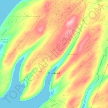
Name: Riverhead topographic map, elevation, terrain.

Location: Riverhead, Newfoundland, Newfoundland and Labrador, Canada (46.93002 -53.57815 47.06263 -53.41132)

Average elevation: 285 ft

Minimum elevation: -7 ft

Maximum elevation: 633 ft

Other topographic maps

Click on a map to view its topography, its elevation and its terrain.

LaScie

Canada > Newfoundland and Labrador

Average elevation: 322 ft

Daniels Gulch

Canada > Newfoundland and Labrador

Average elevation: 1,522 ft

Spot Pond

Canada > Newfoundland and Labrador

Average elevation: 387 ft

Roundabout

Canada > Newfoundland and Labrador

Average elevation: 213 ft

The Peak

Canada > Newfoundland and Labrador

Average elevation: 220 ft

Boat Harbour

Canada > Newfoundland and Labrador

Average elevation: 282 ft

White Horse

Canada > Newfoundland and Labrador

Average elevation: 325 ft

Botwood

Canada > Newfoundland and Labrador > Botwood

Average elevation: 56 ft

Ashuanipi River

Canada > Newfoundland and Labrador

Average elevation: 1,745 ft

Northern

Canada > Newfoundland and Labrador > Deer Lake

Average elevation: 302 ft

The Cabox

Canada > Newfoundland and Labrador

Average elevation: 2,290 ft

Mount Caubvick

Canada > Newfoundland and Labrador

Average elevation: 4,173 ft

Gear up for your next adventure:

🪶Fire Starter Kit - Reliable fire starter for survival and camping
GPS Sports Watch - GPS watch for running, hiking and training
🔋Solar Power Banks - Keep your GPS and phone charged in remote wilderness areas
🖼️Topo Map Wall Art - Decorative topographic prints of famous peaks and regions
🛡️Insect Repellent - Protection against bugs during outdoor activities

As an Amazon Associate, this site earns from qualifying purchases at no extra cost to you.