
Make a donation
Gear up for your next adventure:
As an Amazon Associate, this site earns from qualifying purchases at no extra cost to you.
Ninde topographic map
Click on the map to display elevation.
Make a donation
Gear up for your next adventure:
As an Amazon Associate, this site earns from qualifying purchases at no extra cost to you.
About this map
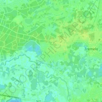
Name: Ninde topographic map, elevation, terrain.
Location: Ninde, Tremelo, Leuven, Vlaams-Brabant, Vlaanderen, 3120, België (50.97107 4.65896 51.01107 4.69896)
Average elevation: 33 ft
Minimum elevation: 13 ft
Maximum elevation: 49 ft
Make a donation
Gear up for your next adventure:
As an Amazon Associate, this site earns from qualifying purchases at no extra cost to you.
Other topographic maps
Click on a map to view its topography, its elevation and its terrain.
Baal
België > Vlaams-Brabant > Leuven > Tremelo
Baal is bekend om zijn Balenberg die bestaat uit twee heuvels, een lage en een hoge, waarvan de lage het meest bekend is en de hoge zo'n 45 meter boven de zeespiegel ligt. De Zuiderkempen ten noorden van de Balenberg zijn overwegend vlak en lemig zandig. Oorspronkelijk was het een bosrijk gebied met…
Average elevation: 43 ft