
Town of Bath topographic map
Interactive map
Click on the map to display elevation.
About this map
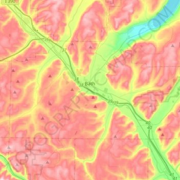
Name: Town of Bath topographic map, elevation, terrain.
Location: Town of Bath, Steuben County, New York, United States (42.27239 -77.44548 42.38688 -77.16169)
Average elevation: 1,476 ft
Minimum elevation: 702 ft
Maximum elevation: 2,070 ft
Other topographic maps
Click on a map to view its topography, its elevation and its terrain.
Town of Wayne
United States > New York > Steuben County
Town of Wayne, Steuben County, New York, 14893, United States
Average elevation: 1,211 ft
City of Corning
United States > New York > Steuben County
City of Corning, Steuben County, New York, United States
Average elevation: 1,102 ft
Town of Wayland
United States > New York > Steuben County
Town of Wayland, Steuben County, New York, United States
Average elevation: 1,647 ft
Marshalls
United States > New York > Steuben County > Town of Wheeler
Marshalls, Town of Wheeler, Steuben County, New York, 14856, United States
Average elevation: 1,526 ft
Town of Bradford
United States > New York > Steuben County
Town of Bradford, Steuben County, New York, United States
Average elevation: 1,490 ft
Town of Hornby
United States > New York > Steuben County
Town of Hornby, Steuben County, New York, 14812, United States
Average elevation: 1,627 ft
Town of Greenwood
United States > New York > Steuben County
Town of Greenwood, Steuben County, New York, 14839, United States
Average elevation: 2,067 ft
Town of Erwin
United States > New York > Steuben County
Town of Erwin, Steuben County, New York, United States
Average elevation: 1,325 ft
Stony Brook State Park
United States > New York > Steuben County
Stony Brook State Park, Town of Dansville, Steuben County, New York, United States
Average elevation: 1,099 ft
Town of Canisteo
United States > New York > Steuben County
Town of Canisteo, Steuben County, New York, 14823, United States
Average elevation: 1,752 ft
Hornby
United States > New York > Steuben County
Hornby, Town of Hornby, Steuben County, New York, United States
Average elevation: 1,742 ft
Painted Post
United States > New York > Steuben County
Painted Post, Town of Erwin, Steuben County, New York, 14870, United States
Average elevation: 1,089 ft
Town of Campbell
United States > New York > Steuben County
Town of Campbell, Steuben County, New York, 14821, United States
Average elevation: 1,381 ft
Risingville
United States > New York > Steuben County > Town of Thurston
Risingville, Town of Thurston, Steuben County, New York, United States
Average elevation: 1,594 ft
Cameron
United States > New York > Steuben County
Cameron, Town of Cameron, Steuben County, New York, 14819, United States
Average elevation: 1,512 ft
Town of Hartsville
United States > New York > Steuben County
Town of Hartsville, Steuben County, New York, United States
Average elevation: 1,955 ft
Village of Avoca
United States > New York > Steuben County > Town of Avoca
Village of Avoca, Town of Avoca, Steuben County, New York, United States
Average elevation: 1,335 ft
Hartsville
United States > New York > Steuben County
Hartsville, Town of Hartsville, Steuben County, New York, United States
Average elevation: 1,854 ft
Atlanta
United States > New York > Steuben County
Atlanta, Town of Cohocton, Steuben County, New York, 14808, United States
Average elevation: 1,493 ft
Pulteney
United States > New York > Steuben County
Pulteney, Town of Pulteney, Steuben County, New York, 14874, United States
Average elevation: 1,047 ft
Troupsburg
United States > New York > Steuben County > Troupsburg
Troupsburg, Town of Troupsburg, Steuben County, New York, 14885, United States
Average elevation: 1,785 ft
Village of Bath
United States > New York > Steuben County > Town of Bath
Village of Bath, Town of Bath, Steuben County, New York, 14810, United States
Average elevation: 1,217 ft
City of Hornell
United States > New York > Steuben County
City of Hornell, Steuben County, New York, 14843, United States
Average elevation: 1,512 ft
Greenwood
United States > New York > Steuben County > Greenwood
Greenwood, Town of Greenwood, Steuben County, New York, 14839, United States
Average elevation: 1,896 ft
Hammondsport
United States > New York > Steuben County > Hammondsport
Hammondsport, Steuben County, New York, United States
Average elevation: 945 ft
Campbell
United States > New York > Steuben County > Campbell
Campbell, Town of Campbell, Steuben County, New York, United States
Average elevation: 1,129 ft
Cameron Mills
United States > New York > Steuben County
Cameron Mills, Town of Rathbone, Steuben County, New York, 14820, United States
Average elevation: 1,411 ft
Village of Addison
United States > New York > Steuben County
Village of Addison, Town of Addison, Steuben County, New York, United States
Average elevation: 1,224 ft