
Make a donation
Gear up for your next adventure:
As an Amazon Associate, this site earns from qualifying purchases at no extra cost to you.
Troupsburg topographic map
Click on the map to display elevation.
Make a donation
Gear up for your next adventure:
As an Amazon Associate, this site earns from qualifying purchases at no extra cost to you.
Troupsburg
The southern town line is the border with Pennsylvania (Tioga County). The town is known for higher elevation than other towns in the county.
Make a donation
Gear up for your next adventure:
As an Amazon Associate, this site earns from qualifying purchases at no extra cost to you.
About this map
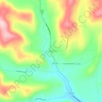
Name: Troupsburg topographic map, elevation, terrain.
Average elevation: 1,785 ft
Minimum elevation: 1,473 ft
Maximum elevation: 2,224 ft
Steuben County trails, hiking, mountain biking, running and outdoor activities
Make a donation
Gear up for your next adventure:
As an Amazon Associate, this site earns from qualifying purchases at no extra cost to you.