
Make a donation
Gear up for your next adventure:
As an Amazon Associate, this site earns from qualifying purchases at no extra cost to you.
Straßdorf topographic map
Click on the map to display elevation.
Make a donation
Gear up for your next adventure:
As an Amazon Associate, this site earns from qualifying purchases at no extra cost to you.
About this map
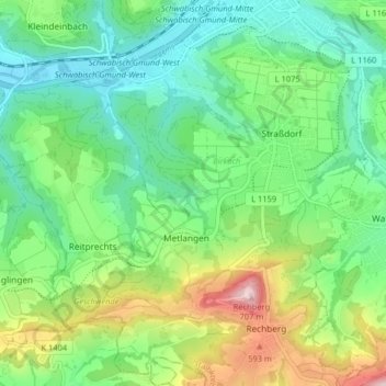
Name: Straßdorf topographic map, elevation, terrain.
Average elevation: 1,391 ft
Minimum elevation: 978 ft
Maximum elevation: 2,320 ft
Make a donation
Gear up for your next adventure:
As an Amazon Associate, this site earns from qualifying purchases at no extra cost to you.
Other topographic maps
Click on a map to view its topography, its elevation and its terrain.
Kleinishof
Deutschland > Baden-Württemberg > Ostalbkreis > Schwäbisch Gmünd > Metlangen
Average elevation: 1,542 ft
Hetzenbühlhof
Deutschland > Baden-Württemberg > Ostalbkreis > Schwäbisch Gmünd > Oberbettringen
Average elevation: 1,352 ft
Wustenriet
Deutschland > Baden-Württemberg > Ostalbkreis > Schwäbisch Gmünd
Average elevation: 1,289 ft
Make a donation
Gear up for your next adventure:
As an Amazon Associate, this site earns from qualifying purchases at no extra cost to you.
Siechenberg
Deutschland > Baden-Württemberg > Ostalbkreis > Schwäbisch Gmünd > Straßdorf
Average elevation: 1,237 ft
Großdeinbach
Deutschland > Baden-Württemberg > Ostalbkreis > Schwäbisch Gmünd
Average elevation: 1,335 ft
Kleindeinbach
Deutschland > Baden-Württemberg > Ostalbkreis > Schwäbisch Gmünd
Average elevation: 1,240 ft
Make a donation
Gear up for your next adventure:
As an Amazon Associate, this site earns from qualifying purchases at no extra cost to you.