
Thank you for supporting this site ❤️
Make a donation
Make a donation
Gear up for your next adventure:
As an Amazon Associate, this site earns from qualifying purchases at no extra cost to you.
Sócota topographic map
Click on the map to display elevation.
Thank you for supporting this site ❤️
Make a donation
Make a donation
Gear up for your next adventure:
As an Amazon Associate, this site earns from qualifying purchases at no extra cost to you.
About this map
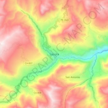
Name: Sócota topographic map, elevation, terrain.
Location: Sócota, Socota, Cutervo, Cajamarca, Perú (-6.35532 -78.73966 -6.27532 -78.65966)
Average elevation: 7,408 ft
Minimum elevation: 5,335 ft
Maximum elevation: 8,996 ft
Thank you for supporting this site ❤️
Make a donation
Make a donation
Gear up for your next adventure:
As an Amazon Associate, this site earns from qualifying purchases at no extra cost to you.