
Make a donation
Gear up for your next adventure:
As an Amazon Associate, this site earns from qualifying purchases at no extra cost to you.
Recoleta topographic map
Click on the map to display elevation.
Make a donation
Gear up for your next adventure:
As an Amazon Associate, this site earns from qualifying purchases at no extra cost to you.
About this map
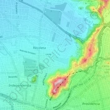
Name: Recoleta topographic map, elevation, terrain.
Average elevation: 1,883 ft
Minimum elevation: 1,667 ft
Maximum elevation: 2,877 ft
Make a donation
Gear up for your next adventure:
As an Amazon Associate, this site earns from qualifying purchases at no extra cost to you.
Other topographic maps
Click on a map to view its topography, its elevation and its terrain.
Santiago
Chile > Santiago Metropolitan Region > Provincia de Santiago > Santiago
The city lies in the center of the Santiago Basin, a large bowl-shaped valley consisting of broad and fertile lands surrounded by mountains. The city has a varying elevation, gradually increasing from 400 m (1,312 ft) in the western areas to more than 700 m (2,297 ft) in the eastern areas. Santiago's…
Average elevation: 2,375 ft