
Make a donation
Gear up for your next adventure:
As an Amazon Associate, this site earns from qualifying purchases at no extra cost to you.
Cranesville topographic map
Click on the map to display elevation.
Make a donation
Gear up for your next adventure:
As an Amazon Associate, this site earns from qualifying purchases at no extra cost to you.
About this map
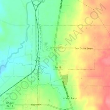
Name: Cranesville topographic map, elevation, terrain.
Location: Cranesville, Erie County, Pennsylvania, United States (41.89575 -80.35147 41.91048 -80.33046)
Average elevation: 965 ft
Minimum elevation: 846 ft
Maximum elevation: 1,102 ft
Erie County trails, hiking, mountain biking, running and outdoor activities
Make a donation
Gear up for your next adventure:
As an Amazon Associate, this site earns from qualifying purchases at no extra cost to you.
Other topographic maps
Click on a map to view its topography, its elevation and its terrain.
East Springfield
United States > Pennsylvania > Erie County > Springfield Township
Average elevation: 751 ft
Reeds Corners
United States > Pennsylvania > Erie County > McKean Township
Average elevation: 1,352 ft
North Springfield
United States > Pennsylvania > Erie County > Springfield Township
Average elevation: 653 ft
Make a donation
Gear up for your next adventure:
As an Amazon Associate, this site earns from qualifying purchases at no extra cost to you.