
Make a donation
Gear up for your next adventure:
As an Amazon Associate, this site earns from qualifying purchases at no extra cost to you.
Anivorano topographic map
Click on the map to display elevation.
Make a donation
Gear up for your next adventure:
As an Amazon Associate, this site earns from qualifying purchases at no extra cost to you.
About this map
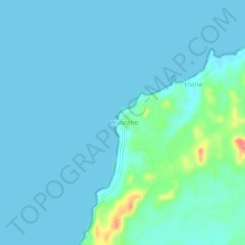
Name: Anivorano topographic map, elevation, terrain.
Average elevation: 30 ft
Minimum elevation: 0 ft
Maximum elevation: 233 ft
Make a donation
Gear up for your next adventure:
As an Amazon Associate, this site earns from qualifying purchases at no extra cost to you.
Other topographic maps
Click on a map to view its topography, its elevation and its terrain.
Île Sainte-Marie
Madagascar > Analanjirofo > District de Nosy Boraha
L'île est relativement élevée : sur sa partie centrale se dresse un prolongement montagneux (altitude maximale 121 m). D'importantes plaines se regroupent sur les parties nord et sud ainsi que dans l'est. Les types de sol varient : ferrallitiques au centre et sablonneux sur les côtes, à faible fertilité,…
Average elevation: 10 ft