
Make a donation
Gear up for your next adventure:
As an Amazon Associate, this site earns from qualifying purchases at no extra cost to you.
Elgin topographic map
Click on the map to display elevation.
Make a donation
Gear up for your next adventure:
As an Amazon Associate, this site earns from qualifying purchases at no extra cost to you.
About this map
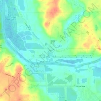
Name: Elgin topographic map, elevation, terrain.
Average elevation: 636 ft
Minimum elevation: 577 ft
Maximum elevation: 741 ft
Ottawa County trails, hiking, mountain biking, running and outdoor activities
Make a donation
Gear up for your next adventure:
As an Amazon Associate, this site earns from qualifying purchases at no extra cost to you.
Other topographic maps
Click on a map to view its topography, its elevation and its terrain.
Zeeland
United States > Michigan > Ottawa County
According to the United States Census Bureau, the city has a total area of 3.01 square miles (7.80 km2), of which 2.99 square miles (7.74 km2) is land and 0.02 square miles (0.05 km2) is water. The town itself is located on a hill, giving the city a higher elevation compared to the surrounding township land.…
Average elevation: 640 ft
Make a donation
Gear up for your next adventure:
As an Amazon Associate, this site earns from qualifying purchases at no extra cost to you.
Make a donation
Gear up for your next adventure:
As an Amazon Associate, this site earns from qualifying purchases at no extra cost to you.