
Make a donation
Gear up for your next adventure:
As an Amazon Associate, this site earns from qualifying purchases at no extra cost to you.
Lesser Poland Voivodeship topographic map
Click on the map to display elevation.
Make a donation
Gear up for your next adventure:
As an Amazon Associate, this site earns from qualifying purchases at no extra cost to you.
About this map
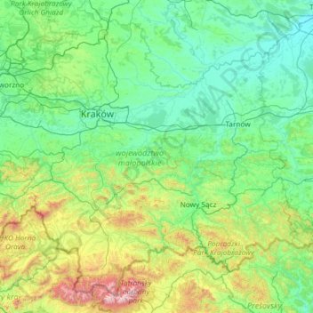
Name: Lesser Poland Voivodeship topographic map, elevation, terrain.
Location: Lesser Poland Voivodeship, Poland (49.17848 19.08312 50.52050 21.42174)
Average elevation: 1,476 ft
Minimum elevation: 489 ft
Maximum elevation: 8,501 ft
Make a donation
Gear up for your next adventure:
As an Amazon Associate, this site earns from qualifying purchases at no extra cost to you.
Other topographic maps
Click on a map to view its topography, its elevation and its terrain.
Sękowiec
Poland > Subcarpathian Voivodeship > Bieszczady County > Zatwarnica
Average elevation: 1,926 ft
Make a donation
Gear up for your next adventure:
As an Amazon Associate, this site earns from qualifying purchases at no extra cost to you.
Kiernozia-Parcela
Poland > Łódź Voivodeship > Łowicz County > Kiernozia > Kiernozia-Parcela
Average elevation: 338 ft
Make a donation
Gear up for your next adventure:
As an Amazon Associate, this site earns from qualifying purchases at no extra cost to you.