
Make a donation
Gear up for your next adventure:
As an Amazon Associate, this site earns from qualifying purchases at no extra cost to you.
Pleret topographic map
Click on the map to display elevation.
Make a donation
Gear up for your next adventure:
As an Amazon Associate, this site earns from qualifying purchases at no extra cost to you.
About this map
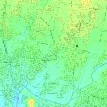
Name: Pleret topographic map, elevation, terrain.
Average elevation: 187 ft
Minimum elevation: 138 ft
Maximum elevation: 240 ft
Make a donation
Gear up for your next adventure:
As an Amazon Associate, this site earns from qualifying purchases at no extra cost to you.
Other topographic maps
Click on a map to view its topography, its elevation and its terrain.
Gunung Malang
Indonesia > Special Region of Yogyakarta > Bantul Regency > Segoroyoso
Average elevation: 246 ft
Jomegatan
Indonesia > Special Region of Yogyakarta > Bantul Regency > Bugisan
Average elevation: 305 ft
Gapuro Gedongkuning
Indonesia > Special Region of Yogyakarta > Bantul Regency > Banguntapan
Average elevation: 338 ft