
Make a donation
Gear up for your next adventure:
As an Amazon Associate, this site earns from qualifying purchases at no extra cost to you.
Fühlingen topographic map
Click on the map to display elevation.
Make a donation
Gear up for your next adventure:
As an Amazon Associate, this site earns from qualifying purchases at no extra cost to you.
Fühlingen
Die von den Franzosen 1798 vorgenommene und von den Preußen 1816 weitgehend übernommene kommunale Neugliederung ließ das Dorf zu einem Teil der Bürgermeisterei Worringen werden. Geändert wurde von den Preußen nur die Zuteilung zum Landkreis: Während die Franzosen die Bürgermeisterei Worringen dem Canton Dormagen zuschlugen, wiesen die Preußen die Bürgermeisterei dem Landkreis Köln zu. Wegen der zentralen Lage des Dorfes innerhalb der Bürgermeisterei befand sich von 1835 bis 1866 der Amtssitz des Bürgermeisters in Fühlingen. Doch die deutlich höhere Einwohnerzahl und der Bahnhof führten zur Rückverlegung nach Worringen.
Make a donation
Gear up for your next adventure:
As an Amazon Associate, this site earns from qualifying purchases at no extra cost to you.
About this map
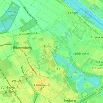
Name: Fühlingen topographic map, elevation, terrain.
Location: Fühlingen, Chorweiler, Köln, Nordrhein-Westfalen, Deutschland (51.01487 6.88359 51.05565 6.94298)
Average elevation: 141 ft
Minimum elevation: 105 ft
Maximum elevation: 180 ft
Make a donation
Gear up for your next adventure:
As an Amazon Associate, this site earns from qualifying purchases at no extra cost to you.
Other topographic maps
Click on a map to view its topography, its elevation and its terrain.
Make a donation
Gear up for your next adventure:
As an Amazon Associate, this site earns from qualifying purchases at no extra cost to you.