
Thank you for supporting this site ❤️
Make a donation
Make a donation
Gear up for your next adventure:
As an Amazon Associate, this site earns from qualifying purchases at no extra cost to you.
Boingt topographic map
Click on the map to display elevation.
Thank you for supporting this site ❤️
Make a donation
Make a donation
Gear up for your next adventure:
As an Amazon Associate, this site earns from qualifying purchases at no extra cost to you.
About this map
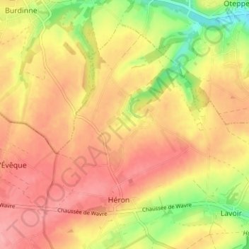
Name: Boingt topographic map, elevation, terrain.
Location: Boingt, Héron, Huy, Liège, Wallonie, 4217, Belgique (50.54285 5.07875 50.58285 5.11875)
Average elevation: 561 ft
Minimum elevation: 377 ft
Maximum elevation: 669 ft
Thank you for supporting this site ❤️
Make a donation
Make a donation
Gear up for your next adventure:
As an Amazon Associate, this site earns from qualifying purchases at no extra cost to you.