
Make a donation
Gear up for your next adventure:
As an Amazon Associate, this site earns from qualifying purchases at no extra cost to you.
El Nido topographic map
Click on the map to display elevation.
Make a donation
Gear up for your next adventure:
As an Amazon Associate, this site earns from qualifying purchases at no extra cost to you.
About this map
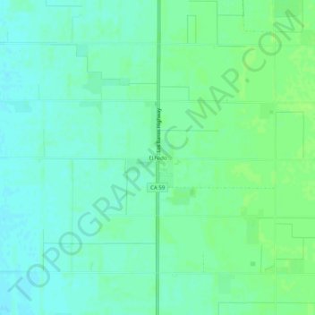
Name: El Nido topographic map, elevation, terrain.
Location: El Nido, Merced County, California, 95317, United States (37.11494 -120.51213 37.15494 -120.47213)
Average elevation: 138 ft
Minimum elevation: 121 ft
Maximum elevation: 154 ft
Merced County trails, hiking, mountain biking, running and outdoor activities
Make a donation
Gear up for your next adventure:
As an Amazon Associate, this site earns from qualifying purchases at no extra cost to you.
Other topographic maps
Click on a map to view its topography, its elevation and its terrain.
Delhi
United States > California > Merced County
Delhi (/ˈdɛlhaɪ/ DEL-hye) is a census-designated place (CDP) in Merced County in the U.S. state of California. Delhi is 18 miles (29 km) west-northwest of Merced, at an elevation of 118 feet (36 m). According to the 2020 census, the population was 10,656.
Average elevation: 128 ft
Berkley Neighborhood Park
United States > California > Merced County > Winton
Average elevation: 180 ft
Planada
United States > California > Merced County
Planada (Spanish for "Plain") is a census-designated place (CDP) in Merced County, California, United States. Planada is 9 miles (14 km) east of Merced, the county seat, at an elevation of 226 feet (69 m). The population was 4,164 at the 2020 census, down from 4,584 at the 2010 census.
Average elevation: 233 ft
Make a donation
Gear up for your next adventure:
As an Amazon Associate, this site earns from qualifying purchases at no extra cost to you.