Geolocate

Ridgely topographic map

Click on the map to display elevation.

About this map

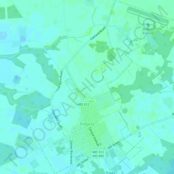
Name: Ridgely topographic map, elevation, terrain.

Location: Ridgely, Caroline County, Maryland, 21660, United States (38.93764 -75.90124 38.97369 -75.85989)

Average elevation: 59 ft

Minimum elevation: 49 ft

Maximum elevation: 69 ft

Caroline County trails, hiking, mountain biking, running and outdoor activities

Other topographic maps

Click on a map to view its topography, its elevation and its terrain.

Choptank

United States > Maryland > Caroline County

Average elevation: 16 ft

Gear up for your next adventure:

🔋Solar Power Banks - Keep your GPS and phone charged in remote wilderness areas
🔭Telescopic Hiking Pole - Adjustable pole for hiking stability
🧤Hiking Gloves - Protective gloves for rugged trails
🛰️Handheld GPS Units - Professional satellite navigators for precise backcountry mapping
🧦Hiking Socks - Comfortable socks to prevent blisters on long hikes

As an Amazon Associate, this site earns from qualifying purchases at no extra cost to you.