Geolocate

Kibler topographic map

Click on the map to display elevation.

About this map

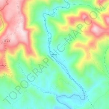
Name: Kibler topographic map, elevation, terrain.

Location: Kibler, Patrick County, Virginia, United States (36.61097 -80.47284 36.65097 -80.43284)

Average elevation: 1,837 ft

Minimum elevation: 1,283 ft

Maximum elevation: 2,736 ft

Other topographic maps

Click on a map to view its topography, its elevation and its terrain.

Stuart

United States > Virginia > Patrick County

Average elevation: 1,348 ft

Fairy Stone Lake

United States > Virginia > Patrick County

Average elevation: 1,109 ft

Stuart

United States > Virginia > Patrick County

Average elevation: 1,365 ft

Patrick Springs

United States > Virginia > Patrick County

Average elevation: 1,276 ft

Stuart

United States > Virginia > Patrick County

Average elevation: 1,348 ft

Gear up for your next adventure:

🍳Camping Cook Set - Complete cookware for outdoor meals
👟Men's Trail Runners - Lightweight footwear for fast-paced exploration and light hiking
🪵Folding Camp Saw - Compact saw for wood and campsite work
🚁Photography Drones - Capture stunning aerial views of landforms and topography
🛰️Satellite Messengers - Emergency SOS and two-way messaging for off-grid adventures

As an Amazon Associate, this site earns from qualifying purchases at no extra cost to you.