
Thank you for supporting this site ❤️
Make a donation
Make a donation
Gear up for your next adventure:
As an Amazon Associate, this site earns from qualifying purchases at no extra cost to you.
Ollantaytambo topographic map
Click on the map to display elevation.
Thank you for supporting this site ❤️
Make a donation
Make a donation
Gear up for your next adventure:
As an Amazon Associate, this site earns from qualifying purchases at no extra cost to you.
Ollantaytambo
Ollantaytambo está localizado no distrito de mesmo nome, província de Urubamba, aproximadamente a 60 quilômetros a noroeste da cidade de Cusco e tem uma altitude de 2.792 metros acima do nível do mar.
Thank you for supporting this site ❤️
Make a donation
Make a donation
Gear up for your next adventure:
As an Amazon Associate, this site earns from qualifying purchases at no extra cost to you.
About this map
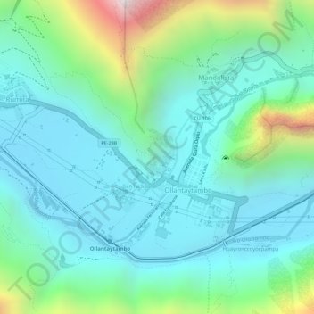
Name: Ollantaytambo topographic map, elevation, terrain.
Average elevation: 9,852 ft
Minimum elevation: 9,140 ft
Maximum elevation: 12,054 ft
Thank you for supporting this site ❤️
Make a donation
Make a donation
Gear up for your next adventure:
As an Amazon Associate, this site earns from qualifying purchases at no extra cost to you.