
Make a donation
Gear up for your next adventure:
As an Amazon Associate, this site earns from qualifying purchases at no extra cost to you.
Punta Umbría topographic map
Click on the map to display elevation.
Make a donation
Gear up for your next adventure:
As an Amazon Associate, this site earns from qualifying purchases at no extra cost to you.
Punta Umbría
Punta Umbría es un municipio español de la provincia de Huelva, Andalucía. El municipio cuenta con una población de 16 167 habitantes (INE 2022). Su extensión superficial es de 38 km² y tiene una densidad de 387,2 hab/km². Se encuentra situada a una altitud de 6 metros y a 20 kilómetros de la capital de provincia, 9km en línea recta, Huelva y a 100 km de Sevilla.
Make a donation
Gear up for your next adventure:
As an Amazon Associate, this site earns from qualifying purchases at no extra cost to you.
About this map
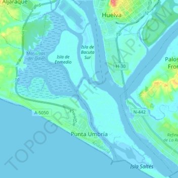
Name: Punta Umbría topographic map, elevation, terrain.
Average elevation: 16 ft
Minimum elevation: -10 ft
Maximum elevation: 177 ft
Make a donation
Gear up for your next adventure:
As an Amazon Associate, this site earns from qualifying purchases at no extra cost to you.
Other topographic maps
Click on a map to view its topography, its elevation and its terrain.
El Portil
España > Andalucía > Comarca Metropolitana de Huelva > Punta Umbría
Average elevation: 39 ft
El Rincón
España > Andalucía > Comarca Metropolitana de Huelva > Punta Umbría
Average elevation: 98 ft
Mazagón
España > Andalucía > Comarca Metropolitana de Huelva > Palos de la Frontera
Average elevation: 36 ft
Make a donation
Gear up for your next adventure:
As an Amazon Associate, this site earns from qualifying purchases at no extra cost to you.
Ría de Punta Umbría
España > Andalucía > Comarca Metropolitana de Huelva > Punta Umbría
Average elevation: 10 ft
La Rábida
España > Andalucía > Comarca Metropolitana de Huelva > Palos de la Frontera
Average elevation: 33 ft
Parque Rústico "La Dehesa"
España > Andalucía > Comarca Metropolitana de Huelva > Aljaraque > Dehesa Golf
Average elevation: 52 ft
Make a donation
Gear up for your next adventure:
As an Amazon Associate, this site earns from qualifying purchases at no extra cost to you.
Los Centenales
España > Andalucía > Comarca Metropolitana de Huelva > Gibraleón
Average elevation: 164 ft
Make a donation
Gear up for your next adventure:
As an Amazon Associate, this site earns from qualifying purchases at no extra cost to you.
Marismas del Odiel
España > Andalucía > Comarca Metropolitana de Huelva > Punta Umbría
Average elevation: 23 ft
Bermejal
España > Andalucía > Comarca Metropolitana de Huelva > San Juan del Puerto
Average elevation: 33 ft
Poblado Forestal
España > Andalucía > Comarca Metropolitana de Huelva > Moguer
Average elevation: 112 ft
Make a donation
Gear up for your next adventure:
As an Amazon Associate, this site earns from qualifying purchases at no extra cost to you.