
Make a donation
Gear up for your next adventure:
As an Amazon Associate, this site earns from qualifying purchases at no extra cost to you.
Eberstadt topographic map
Click on the map to display elevation.
Make a donation
Gear up for your next adventure:
As an Amazon Associate, this site earns from qualifying purchases at no extra cost to you.
About this map
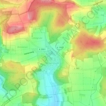
Name: Eberstadt topographic map, elevation, terrain.
Average elevation: 1,155 ft
Minimum elevation: 991 ft
Maximum elevation: 1,335 ft
Make a donation
Gear up for your next adventure:
As an Amazon Associate, this site earns from qualifying purchases at no extra cost to you.
Other topographic maps
Click on a map to view its topography, its elevation and its terrain.
Hettigenbeuern
Deutschland > Baden-Württemberg > Neckar-Odenwald-Kreis > Buchen (Odenwald) > Hettigenbeuern
Average elevation: 1,257 ft
Eberstadter Tropfsteinhöhle
Deutschland > Baden-Württemberg > Neckar-Odenwald-Kreis > Buchen (Odenwald) > Eberstadt
Der Besuchergang führt an verschiedenen Tropfsteinformationen vorbei tief ins Innere der Höhle; nur das äußerste Ende ist nicht mehr begehbar. Im vorderen Teil der Höhle fällt die höhenabhängig unterschiedliche Ausprägung der Höhlenwände auf. Im oberen Wandbereich befinden sich runde Formen,…
Average elevation: 1,161 ft
Götzingen
Deutschland > Baden-Württemberg > Neckar-Odenwald-Kreis > Buchen (Odenwald)
Average elevation: 1,175 ft
Hainstadt
Deutschland > Baden-Württemberg > Neckar-Odenwald-Kreis > Buchen (Odenwald)
Average elevation: 1,283 ft
Make a donation
Gear up for your next adventure:
As an Amazon Associate, this site earns from qualifying purchases at no extra cost to you.
Siedlung Am Kaltenberg
Deutschland > Baden-Württemberg > Neckar-Odenwald-Kreis > Buchen (Odenwald)
Average elevation: 1,201 ft