
Make a donation
Gear up for your next adventure:
As an Amazon Associate, this site earns from qualifying purchases at no extra cost to you.
Hagwilget topographic map
Click on the map to display elevation.
Make a donation
Gear up for your next adventure:
As an Amazon Associate, this site earns from qualifying purchases at no extra cost to you.
About this map
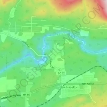
Name: Hagwilget topographic map, elevation, terrain.
Average elevation: 1,106 ft
Minimum elevation: 702 ft
Maximum elevation: 2,011 ft
Make a donation
Gear up for your next adventure:
As an Amazon Associate, this site earns from qualifying purchases at no extra cost to you.
Other topographic maps
Click on a map to view its topography, its elevation and its terrain.
Swan Lake
Canada > British Columbia > Regional District of Kitimat-Stikine > Area B (Suskwa/Kitwanga/Kispiox)
Average elevation: 1,772 ft
Affleck Lake
Canada > British Columbia > Regional District of Kitimat-Stikine > Area B (Suskwa/Kitwanga/Kispiox)
Average elevation: 1,368 ft
Pentz Lake
Canada > British Columbia > Regional District of Kitimat-Stikine > Area B (Suskwa/Kitwanga/Kispiox)
Average elevation: 1,168 ft