
Elderslie topographic map
Interactive map
Click on the map to display elevation.
About this map
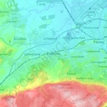
Name: Elderslie topographic map, elevation, terrain.
Location: Elderslie, Renfrewshire, Scotland, PA5 9EP, United Kingdom (55.79679 -4.52406 55.87679 -4.44406)
Average elevation: 200 ft
Minimum elevation: -7 ft
Maximum elevation: 768 ft
Other topographic maps
Click on a map to view its topography, its elevation and its terrain.
Paisley
United Kingdom > Scotland > Renfrewshire
Paisley, Renfrewshire, Scotland, PA1 1DG, United Kingdom
Average elevation: 108 ft
Lochwinnoch
United Kingdom > Scotland > Renfrewshire
Lochwinnoch, Renfrewshire, Scotland, PA12 4DA, United Kingdom
Average elevation: 266 ft
Bridge of Weir
United Kingdom > Scotland > Renfrewshire
Bridge of Weir, Renfrewshire, Scotland, PA11 3NU, United Kingdom
Average elevation: 256 ft
Renfrew
United Kingdom > Scotland > Renfrewshire
Renfrew, Renfrewshire, Scotland, PA4 8TU, United Kingdom
Average elevation: 52 ft
Brookfield
United Kingdom > Scotland > Renfrewshire > Johnstone > Brookfield
Brookfield, Johnstone, Renfrewshire, Scotland, PA5 8UE, United Kingdom
Average elevation: 115 ft
Kilbarchan
United Kingdom > Scotland > Renfrewshire
Kilbarchan, Renfrewshire, Scotland, PA10 2JE, United Kingdom
Average elevation: 207 ft
Johnstone
United Kingdom > Scotland > Renfrewshire
Johnstone, Renfrewshire, Scotland, PA5 8DT, United Kingdom
Average elevation: 213 ft
Houston
United Kingdom > Scotland > Renfrewshire
Houston, Renfrewshire, Scotland, PA6 7DZ, United Kingdom
Average elevation: 138 ft
Langbank
United Kingdom > Scotland > Renfrewshire
Langbank, Renfrewshire, Scotland, PA14 6YA, United Kingdom
Average elevation: 184 ft
Inchinnan
United Kingdom > Scotland > Renfrewshire
Inchinnan, Renfrewshire, Scotland, PA4 9QG, United Kingdom
Average elevation: 36 ft