
Make a donation
Gear up for your next adventure:
As an Amazon Associate, this site earns from qualifying purchases at no extra cost to you.
Simonswood topographic map
Click on the map to display elevation.
Make a donation
Gear up for your next adventure:
As an Amazon Associate, this site earns from qualifying purchases at no extra cost to you.
About this map
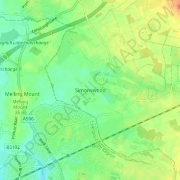
Name: Simonswood topographic map, elevation, terrain.
Average elevation: 118 ft
Minimum elevation: 66 ft
Maximum elevation: 184 ft
Make a donation
Gear up for your next adventure:
As an Amazon Associate, this site earns from qualifying purchases at no extra cost to you.
Other topographic maps
Click on a map to view its topography, its elevation and its terrain.
Bispham
United Kingdom > England > Lancashire > West Lancashire > Bispham Green
Average elevation: 85 ft
Up Holland
United Kingdom > England > Lancashire > West Lancashire > Upholland
Average elevation: 292 ft
Make a donation
Gear up for your next adventure:
As an Amazon Associate, this site earns from qualifying purchases at no extra cost to you.
Scarisbrick
United Kingdom > England > Lancashire > West Lancashire > Scarisbrick
Average elevation: 39 ft
Make a donation
Gear up for your next adventure:
As an Amazon Associate, this site earns from qualifying purchases at no extra cost to you.
Aughton
United Kingdom > England > Lancashire > West Lancashire > Town Green
Average elevation: 128 ft
Bury Hey Wood
United Kingdom > England > Lancashire > West Lancashire > Appley Bridge > Robin Hood
Average elevation: 348 ft
Make a donation
Gear up for your next adventure:
As an Amazon Associate, this site earns from qualifying purchases at no extra cost to you.
Bickerstaffe
United Kingdom > England > Lancashire > West Lancashire > Bickerstaffe
Average elevation: 167 ft
Make a donation
Gear up for your next adventure:
As an Amazon Associate, this site earns from qualifying purchases at no extra cost to you.
Bury Hey Wood
United Kingdom > England > Lancashire > West Lancashire > Appley Bridge > Robin Hood
Average elevation: 348 ft
Make a donation
Gear up for your next adventure:
As an Amazon Associate, this site earns from qualifying purchases at no extra cost to you.
Aughton
United Kingdom > England > Lancashire > West Lancashire > Town Green
Average elevation: 128 ft