
Make a donation
Gear up for your next adventure:
As an Amazon Associate, this site earns from qualifying purchases at no extra cost to you.
Harwell topographic map
Click on the map to display elevation.
Make a donation
Gear up for your next adventure:
As an Amazon Associate, this site earns from qualifying purchases at no extra cost to you.
About this map
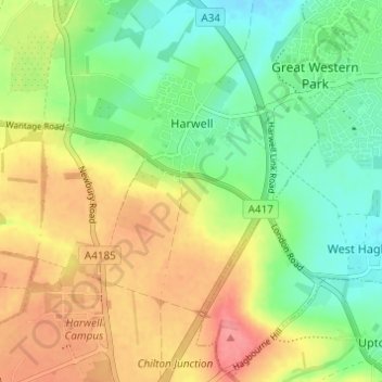
Name: Harwell topographic map, elevation, terrain.
Average elevation: 295 ft
Minimum elevation: 171 ft
Maximum elevation: 449 ft
Make a donation
Gear up for your next adventure:
As an Amazon Associate, this site earns from qualifying purchases at no extra cost to you.
Other topographic maps
Click on a map to view its topography, its elevation and its terrain.
Harrowdown Hill
United Kingdom > England > Oxfordshire > Vale of White Horse
Average elevation: 243 ft
Lamborough Hill
United Kingdom > England > Oxfordshire > Vale of White Horse > Dry Sandford > Lamborough Hill
Average elevation: 302 ft
Make a donation
Gear up for your next adventure:
As an Amazon Associate, this site earns from qualifying purchases at no extra cost to you.
Milton Heights
United Kingdom > England > Oxfordshire > Vale of White Horse > Milton
Average elevation: 236 ft