
Make a donation
Gear up for your next adventure:
As an Amazon Associate, this site earns from qualifying purchases at no extra cost to you.
Penha topographic map
Click on the map to display elevation.
Make a donation
Gear up for your next adventure:
As an Amazon Associate, this site earns from qualifying purchases at no extra cost to you.
About this map
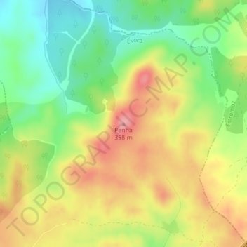
Name: Penha topographic map, elevation, terrain.
Location: Penha, Évora, 7040-301, Portugal (38.74552 -7.78164 38.74562 -7.78154)
Average elevation: 971 ft
Minimum elevation: 801 ft
Maximum elevation: 1,152 ft
Make a donation
Gear up for your next adventure:
As an Amazon Associate, this site earns from qualifying purchases at no extra cost to you.
Other topographic maps
Click on a map to view its topography, its elevation and its terrain.
Make a donation
Gear up for your next adventure:
As an Amazon Associate, this site earns from qualifying purchases at no extra cost to you.
Aqueduto da Água de Prata
A paisagem que acompanha o aqueduto entre as Muralhas Fernandinas de Évora e as nascentes, num vale próximo da Igreja Paroquial de Nossa Senhora da Graça do Divor (Graça do Divor, Évora), nos campos do Convento São Bento de Castris, apresenta uma diversidade que passa por grandes áreas de pastagens e…
Average elevation: 1,030 ft