
Make a donation
Gear up for your next adventure:
As an Amazon Associate, this site earns from qualifying purchases at no extra cost to you.
Bière topographic map
Click on the map to display elevation.
Make a donation
Gear up for your next adventure:
As an Amazon Associate, this site earns from qualifying purchases at no extra cost to you.
Bière
Bière est un village situé sur un plateau au pied du Jura. La commune s'étage d'une altitude de 569 mètres à la confluence du Toleure et de l'Aubonne à 1 606 mètres au Grand Cunay. Le Veyron et l'Aubonne prennent leur source sur la commune de Bière.
Make a donation
Gear up for your next adventure:
As an Amazon Associate, this site earns from qualifying purchases at no extra cost to you.
About this map
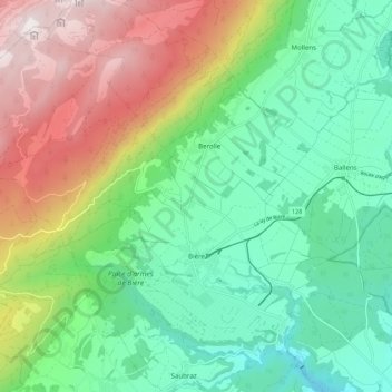
Name: Bière topographic map, elevation, terrain.
Location: Bière, District de Morges, Vaud, 1145, Suisse (46.51648 6.26454 46.58118 6.37328)
Average elevation: 2,982 ft
Minimum elevation: 1,772 ft
Maximum elevation: 5,276 ft
Make a donation
Gear up for your next adventure:
As an Amazon Associate, this site earns from qualifying purchases at no extra cost to you.
Other topographic maps
Click on a map to view its topography, its elevation and its terrain.
Make a donation
Gear up for your next adventure:
As an Amazon Associate, this site earns from qualifying purchases at no extra cost to you.