
Cullybackey topographic map
Click on the map to display elevation.
About this map
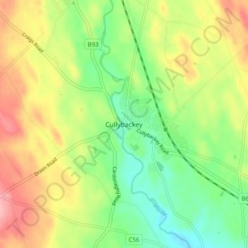
Name: Cullybackey topographic map, elevation, terrain.
Average elevation: 302 ft
Minimum elevation: 135 ft
Maximum elevation: 512 ft
Other topographic maps
Click on a map to view its topography, its elevation and its terrain.
Rathlin Island
United Kingdom > Northern Ireland > County Antrim > Church Bay
Average elevation: 33 ft
Loughgiel Millennium Centre
United Kingdom > Northern Ireland > County Antrim > Loughguile
Average elevation: 509 ft
Causeway Coast AONB
United Kingdom > Northern Ireland > County Antrim > Ballintoy
Average elevation: 112 ft
Shane's Castle Park
United Kingdom > Northern Ireland > County Antrim > Randalstown
Average elevation: 98 ft
Lagan Navigation (Abandoned)
United Kingdom > Northern Ireland > County Antrim > Belfast
Average elevation: 95 ft
Mid and East Antrim District
United Kingdom > Northern Ireland > County Antrim
Average elevation: 364 ft
Antrim and Newtownabbey District
United Kingdom > Northern Ireland > County Antrim
Average elevation: 318 ft
Kinbane Castle
United Kingdom > Northern Ireland > County Antrim > Ballycastle
Average elevation: 121 ft
Mid and East Antrim District
United Kingdom > Northern Ireland > County Antrim
Average elevation: 364 ft
Rathlin Island
United Kingdom > Northern Ireland > County Antrim > Church Bay
Average elevation: 33 ft
Antrim and Newtownabbey District
United Kingdom > Northern Ireland > County Antrim
Average elevation: 318 ft
Mid and East Antrim District
United Kingdom > Northern Ireland > County Antrim
Average elevation: 364 ft
Antrim and Newtownabbey District
United Kingdom > Northern Ireland > County Antrim
Average elevation: 318 ft