Geolocate

Valley topographic map

Click on the map to display elevation.

About this map

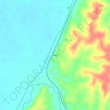
Name: Valley topographic map, elevation, terrain.

Location: Valley, Yazoo County, Mississippi, 39173, United States (32.73986 -90.50037 32.77986 -90.46037)

Average elevation: 161 ft

Minimum elevation: 89 ft

Maximum elevation: 331 ft

Other topographic maps

Click on a map to view its topography, its elevation and its terrain.

Yazoo City

United States > Mississippi > Yazoo County

Average elevation: 148 ft

Satartia

United States > Mississippi > Yazoo County

Average elevation: 125 ft

Satartia

United States > Mississippi > Yazoo County

Average elevation: 125 ft

Gear up for your next adventure:

🧴Hand Sanitizer - Keep hands clean while hiking
👓Polarized Sunglasses - Outdoor sunglasses for glare reduction
🔋Rechargeable Batteries - Power up your outdoor devices
🧦Hiking Socks - Comfortable socks to prevent blisters on long hikes
🧥Men's Rain Shells - Premium waterproof and breathable jackets for mountain weather

As an Amazon Associate, this site earns from qualifying purchases at no extra cost to you.