Geolocate

Dawagung topographic map

Click on the map to display elevation.

About this map

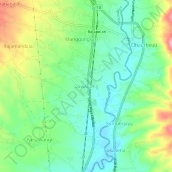
Name: Dawagung topographic map, elevation, terrain.

Location: Dawagung, Tasikmalaya, West Java, Java, 46262, Indonesia (-7.25353 108.16871 -7.21353 108.20871)

Average elevation: 1,529 ft

Minimum elevation: 1,368 ft

Maximum elevation: 1,827 ft

Other topographic maps

Click on a map to view its topography, its elevation and its terrain.

Cipanas

Indonesia > West Java > Tasikmalaya

Average elevation: 384 ft

Desa Arjasari

Indonesia > West Java > Tasikmalaya

Average elevation: 1,490 ft

Desa Cimanuk

Indonesia > West Java > Tasikmalaya

Average elevation: 105 ft

Gear up for your next adventure:

🛠️Backpacking Tool Kit - Essential toolkit for outdoor repairs
🧷Carabiner Set - Durable clips for gear attachment
🔋Rechargeable Batteries - Power up your outdoor devices
📱Heavy-Duty Phone Cases - Drop-proof and waterproof protection for outdoor navigation
🚪Portable Camp Chair - Foldable chair for comfort at camp

As an Amazon Associate, this site earns from qualifying purchases at no extra cost to you.