
Beaverton topographic map
Interactive map
Click on the map to display elevation.
About this map
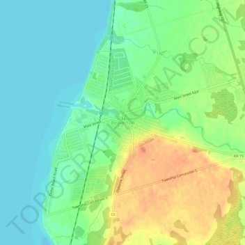
Name: Beaverton topographic map, elevation, terrain.
Average elevation: 758 ft
Minimum elevation: 705 ft
Maximum elevation: 837 ft
Other topographic maps
Click on a map to view its topography, its elevation and its terrain.
Cannington
Canada > Ontario > Durham Region > Brock
Cannington, Brock, Durham Region, Golden Horseshoe, Ontario, L0E 1E0, Canada
Average elevation: 863 ft
Sunderland
Canada > Ontario > Durham Region > Brock
Sunderland, Brock, Durham Region, Golden Horseshoe, Ontario, L0C 1H0, Canada
Average elevation: 909 ft