
Make a donation
Gear up for your next adventure:
As an Amazon Associate, this site earns from qualifying purchases at no extra cost to you.
Cittanova topographic map
Click on the map to display elevation.
Make a donation
Gear up for your next adventure:
As an Amazon Associate, this site earns from qualifying purchases at no extra cost to you.
Cittanova
The altitude referring to the town hall building is 400 meters above mean sea level, in the municipal area the minimum altitude reaches 77 m above mean sea level while the maximum reaches 996 meters. The surface is 61.98 km² (about 65% in flat land planted with olive trees and 35% in mountainous wooded land and natural pastures).
Make a donation
Gear up for your next adventure:
As an Amazon Associate, this site earns from qualifying purchases at no extra cost to you.
About this map
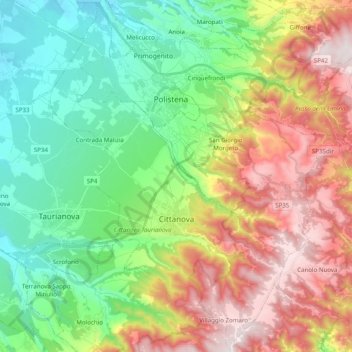
Name: Cittanova topographic map, elevation, terrain.
Location: Cittanova, Reggio Calabria, Calabria, 89022, Italy (38.29537 16.00404 38.45003 16.14346)
Average elevation: 1,430 ft
Minimum elevation: 249 ft
Maximum elevation: 3,304 ft
Make a donation
Gear up for your next adventure:
As an Amazon Associate, this site earns from qualifying purchases at no extra cost to you.
Other topographic maps
Click on a map to view its topography, its elevation and its terrain.