
Make a donation
Gear up for your next adventure:
As an Amazon Associate, this site earns from qualifying purchases at no extra cost to you.
Riace Marina topographic map
Click on the map to display elevation.
Make a donation
Gear up for your next adventure:
As an Amazon Associate, this site earns from qualifying purchases at no extra cost to you.
About this map
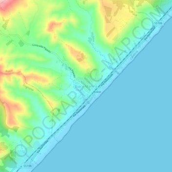
Name: Riace Marina topographic map, elevation, terrain.
Location: Riace Marina, Riace, Reggio Calabria, Calabria, 89040, Italy (38.36962 16.50487 38.40962 16.54487)
Average elevation: 118 ft
Minimum elevation: -3 ft
Maximum elevation: 535 ft
Make a donation
Gear up for your next adventure:
As an Amazon Associate, this site earns from qualifying purchases at no extra cost to you.
Other topographic maps
Click on a map to view its topography, its elevation and its terrain.
Cittanova
Italy > Calabria > Reggio Calabria
The altitude referring to the town hall building is 400 meters above mean sea level, in the municipal area the minimum altitude reaches 77 m above mean sea level while the maximum reaches 996 meters. The surface is 61.98 km² (about 65% in flat land planted with olive trees and 35% in mountainous wooded land…
Average elevation: 1,430 ft
Make a donation
Gear up for your next adventure:
As an Amazon Associate, this site earns from qualifying purchases at no extra cost to you.