
Make a donation
Gear up for your next adventure:
As an Amazon Associate, this site earns from qualifying purchases at no extra cost to you.
Maymana topographic map
Click on the map to display elevation.
Make a donation
Gear up for your next adventure:
As an Amazon Associate, this site earns from qualifying purchases at no extra cost to you.
Maymana
Maymana is located at the northern foot of the Torkestan Range at an elevation of 877 m (2,877 ft) on the old terrace of the Qeysar or Maymana River, which is a right tributary of the Murghab River. The Maymana River branches off of the Band-e Turkistan River 50 km south of the city. The highlands of the Maymana region generally possess a very rich topsoil which supports the seasonal agricultural activities.
Make a donation
Gear up for your next adventure:
As an Amazon Associate, this site earns from qualifying purchases at no extra cost to you.
About this map
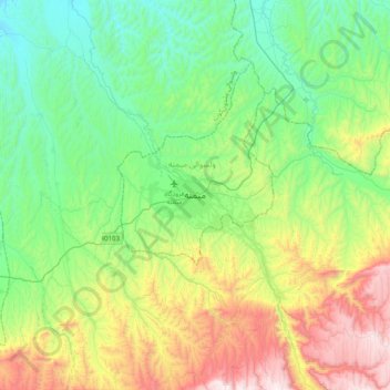
Name: Maymana topographic map, elevation, terrain.
Location: Maymana, Faryab Province, Afghanistan (35.76039 64.62225 36.08039 64.94225)
Average elevation: 3,245 ft
Minimum elevation: 1,972 ft
Maximum elevation: 6,142 ft
Make a donation
Gear up for your next adventure:
As an Amazon Associate, this site earns from qualifying purchases at no extra cost to you.