
Cajetina Municipality topographic map
Interactive map
Click on the map to display elevation.
About this map
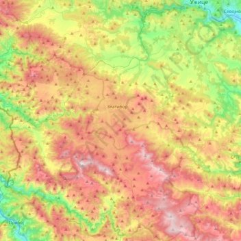
Name: Cajetina Municipality topographic map, elevation, terrain.
Average elevation: 2,904 ft
Minimum elevation: 1,161 ft
Maximum elevation: 4,859 ft
Other topographic maps
Click on a map to view its topography, its elevation and its terrain.
Ђаловића клисура
Serbia > Central Serbia > Zlatibor Administrative District > Sjenica Municipality > Crvsko
Average elevation: 3,579 ft
Zlatar
Serbia > Central Serbia > Zlatibor Administrative District > Prijepolje Municipality
Zlatar (Serbian Cyrillic: Златар, pronounced [zlǎtaːr]) is a mountain range in southwestern Serbia, lying between towns of Prijepolje and Nova Varoš. Its highest peak is Velika krseva, 1,627 meters tall, peak next to Golo brdo. It belongs to Stari Vlah group of Dinaric Alps. Zlatar is bounded by…
Average elevation: 4,718 ft
Tara
Serbia > Central Serbia > Zlatibor Administrative District > Uzice
Tara (Serbian Cyrillic: Тара, pronounced [târa]) is a mountain in western Serbia. It is part of the Dinaric Alps and stands at 1,000 to 1,590 m (3,280 to 5,220 ft) above sea level. The mountain's slopes are clad in dense forests with numerous high-elevation clearings and meadows, steep cliffs, deep…
Average elevation: 4,347 ft
Маслаћи
Serbia > Central Serbia > Zlatibor Administrative District > Pozega Municipality > Donja Dobrinja
Average elevation: 1,588 ft
Mitrovac na Tari
Serbia > Central Serbia > Zlatibor Administrative District > Bajina Basta Municipality > Perucac
Average elevation: 3,724 ft
Награмак
Serbia > Central Serbia > Zlatibor Administrative District > Bajina Basta Municipality > Beserovina
Average elevation: 3,957 ft
Usak
Serbia > Central Serbia > Zlatibor Administrative District > Sjenica Municipality
Average elevation: 3,593 ft
Dobroselica
Serbia > Central Serbia > Zlatibor Administrative District > Cajetina Municipality
Average elevation: 3,186 ft
Citluk
Serbia > Central Serbia > Zlatibor Administrative District > Sjenica Municipality
Average elevation: 3,848 ft
Priboj
Serbia > Central Serbia > Zlatibor Administrative District > Priboj Municipality
Average elevation: 2,234 ft
Sirogojno
Serbia > Central Serbia > Zlatibor Administrative District > Cajetina Municipality > Sirogojno
Average elevation: 2,844 ft
Cajetina
Serbia > Central Serbia > Zlatibor Administrative District > Cajetina Municipality
Average elevation: 2,913 ft
Zlatibor
Serbia > Central Serbia > Zlatibor Administrative District > Cajetina Municipality
Zlatibor itself is located in the northern part of the Stari Vlah region, a historical border region between Raška, Herzegovina and Bosnia. It spreads over an area of 300 square kilometres (120 square miles), 43 km (27 mi) in length, southeast to northwest, and up to 37 km (23 mi) in width. Its highest peak,…
Average elevation: 3,996 ft
Bukovik
Serbia > Central Serbia > Zlatibor Administrative District > Prijepolje Municipality > Bukovik
Average elevation: 2,457 ft