
Make a donation
Gear up for your next adventure:
As an Amazon Associate, this site earns from qualifying purchases at no extra cost to you.
Ashwicken topographic map
Click on the map to display elevation.
Make a donation
Gear up for your next adventure:
As an Amazon Associate, this site earns from qualifying purchases at no extra cost to you.
About this map
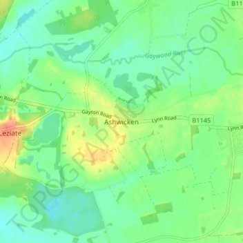
Name: Ashwicken topographic map, elevation, terrain.
Average elevation: 56 ft
Minimum elevation: 0 ft
Maximum elevation: 157 ft
Make a donation
Gear up for your next adventure:
As an Amazon Associate, this site earns from qualifying purchases at no extra cost to you.
Other topographic maps
Click on a map to view its topography, its elevation and its terrain.
Terrington St. Clement
United Kingdom > England > Norfolk > King's Lynn and West Norfolk
Average elevation: 7 ft
Downham Market
United Kingdom > England > Norfolk > King's Lynn and West Norfolk
Average elevation: 66 ft
Make a donation
Gear up for your next adventure:
As an Amazon Associate, this site earns from qualifying purchases at no extra cost to you.
Burn
United Kingdom > England > Norfolk > King's Lynn and West Norfolk > Burnham Overy
Average elevation: 52 ft
Make a donation
Gear up for your next adventure:
As an Amazon Associate, this site earns from qualifying purchases at no extra cost to you.
Burnham Market
United Kingdom > England > Norfolk > King's Lynn and West Norfolk
Average elevation: 144 ft