
Riotorto topographic map
Interactive map
Click on the map to display elevation.
About this map
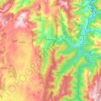
Name: Riotorto topographic map, elevation, terrain.
Location: Riotorto, Meira, Lugo, Galicia, España (43.25188 -7.31976 43.39938 -7.20352)
Average elevation: 1,460 ft
Minimum elevation: 171 ft
Maximum elevation: 2,710 ft
Other topographic maps
Click on a map to view its topography, its elevation and its terrain.
O Vilar de Santiago
España > Galicia > Riotorto > O Vilar de Santiago
O Vilar de Santiago, A Muxueira, Riotorto, Meira, Lugo, Galicia, 27743, España
Average elevation: 1,535 ft
As Rodrigas
España > Galicia > Riotorto > As Rodrigas
As Rodrigas, Riotorto, Meira, Galicia, 27744, España
Average elevation: 1,060 ft
A Ribadiña
España > Galicia > Riotorto > A Ribadiña
A Ribadiña, Ferreiravella, Riotorto, Meira, Lugo, Galicia, 27744, España
Average elevation: 1,601 ft