
Make a donation
Gear up for your next adventure:
As an Amazon Associate, this site earns from qualifying purchases at no extra cost to you.
Diana topographic map
Click on the map to display elevation.
Make a donation
Gear up for your next adventure:
As an Amazon Associate, this site earns from qualifying purchases at no extra cost to you.
About this map
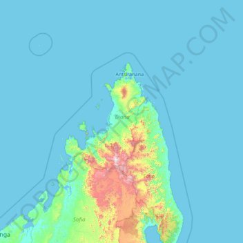
Name: Diana topographic map, elevation, terrain.
Location: Diana, Antsiranana Province, Madagascar (-15.80438 46.51114 -10.60438 51.71114)
Average elevation: 397 ft
Minimum elevation: -3 ft
Maximum elevation: 9,019 ft
Make a donation
Gear up for your next adventure:
As an Amazon Associate, this site earns from qualifying purchases at no extra cost to you.
Other topographic maps
Click on a map to view its topography, its elevation and its terrain.
Marojejy National Park
Madagascar > Antsiranana Province > District de Sambava
Marojejy National Park (/məˈroʊdʒɛdʒiː/) is a national park in the Sava region of northeastern Madagascar. It covers 55,500 ha (214 sq mi) and is centered on the Marojejy Massif, a mountain chain that rises to an elevation of 2,132 m (6,995 ft). Access to the area around the massif was restricted to…
Average elevation: 2,215 ft