
Make a donation
Gear up for your next adventure:
As an Amazon Associate, this site earns from qualifying purchases at no extra cost to you.
Geilenkirchen topographic map
Click on the map to display elevation.
Make a donation
Gear up for your next adventure:
As an Amazon Associate, this site earns from qualifying purchases at no extra cost to you.
Geilenkirchen
Die Stadt erstreckt sich beiderseits der Wurm auf den sanft ansteigenden Hängen des Wurmtales, die sich von 70 m über NHN auf Flussniveau bis auf rund 100 m Höhe erheben. Geilenkirchen erstreckt sich über 9,5 km in Nord-Süd-Richtung und über 15,4 km Ost-West-Richtung.
Make a donation
Gear up for your next adventure:
As an Amazon Associate, this site earns from qualifying purchases at no extra cost to you.
About this map
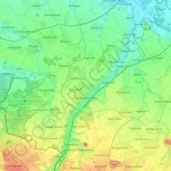
Name: Geilenkirchen topographic map, elevation, terrain.
Average elevation: 295 ft
Minimum elevation: 141 ft
Maximum elevation: 646 ft
Make a donation
Gear up for your next adventure:
As an Amazon Associate, this site earns from qualifying purchases at no extra cost to you.
Other topographic maps
Click on a map to view its topography, its elevation and its terrain.
Myhl
Deutschland > Nordrhein-Westfalen > Kreis Heinsberg > Wassenberg
Myhl liegt ähnlich wie das benachbarte Altmyhl in einem Nebental der Rur zwischen Gerderath und Wassenberg und gehört zum Wassenberger Riedelland. Der höchste Punkt liegt etwa bei 95 Metern über NN. Der Myhler Bach ist heute weitgehend verrohrt, durchzieht jedoch die gesamte Ortschaft entlang der…
Average elevation: 269 ft