
Reigate topographic map
Click on the map to display elevation.
Reigate
Reigate is in central Surrey, around 19 mi (30 km) south of central London and 9 mi (14 km) north of Gatwick Airport. The town is in the Vale of Holmesdale, below the North Downs escarpment. The average elevation in the centre is 80 m (260 ft) above ordnance datum (OD) and the area is drained by the Wallace Brook and its tributaries, which feed the River Mole.
About this map
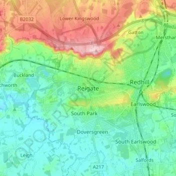
Name: Reigate topographic map, elevation, terrain.
Average elevation: 328 ft
Minimum elevation: 141 ft
Maximum elevation: 774 ft
Other topographic maps
Click on a map to view its topography, its elevation and its terrain.
Lower Earlswood Lake
United Kingdom > England > Surrey > Reigate and Banstead > Redhill
Average elevation: 246 ft
Redhill Common
United Kingdom > England > Surrey > Reigate and Banstead > Redhill
Average elevation: 302 ft
Banstead Wood
United Kingdom > England > Surrey > Reigate and Banstead > Chipstead
Average elevation: 476 ft
Reigate Park
United Kingdom > England > Surrey > Reigate and Banstead > Reigate
Average elevation: 262 ft
Horley
United Kingdom > England > Surrey > Reigate and Banstead
Horley is at an altitude of around 54 m (177 ft) above mean sea level.
Average elevation: 190 ft