
Thank you for supporting this site ❤️
Make a donation
Make a donation
Gear up for your next adventure:
As an Amazon Associate, this site earns from qualifying purchases at no extra cost to you.
Villora topographic map
Click on the map to display elevation.
Thank you for supporting this site ❤️
Make a donation
Make a donation
Gear up for your next adventure:
As an Amazon Associate, this site earns from qualifying purchases at no extra cost to you.
About this map
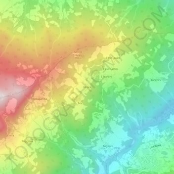
Name: Villora topographic map, elevation, terrain.
Location: Villora, Varsi, Parma, Emilia-Romagna, 43049, Italia (44.65919 9.80710 44.69919 9.84710)
Average elevation: 1,923 ft
Minimum elevation: 935 ft
Maximum elevation: 3,317 ft
Thank you for supporting this site ❤️
Make a donation
Make a donation
Gear up for your next adventure:
As an Amazon Associate, this site earns from qualifying purchases at no extra cost to you.