
Make a donation
Gear up for your next adventure:
As an Amazon Associate, this site earns from qualifying purchases at no extra cost to you.
Neckeroda topographic map
Click on the map to display elevation.
Make a donation
Gear up for your next adventure:
As an Amazon Associate, this site earns from qualifying purchases at no extra cost to you.
Neckeroda
Das Bauerndorf liegt 5,5 km südlich von Blankenhain auf einer mittleren Höhe von 465 m NN auf einer kupierten Hochebene. Die höchste Erhebung ist 477,7 m NN. Die Bundesstraße 85 führt im östlichen Dorfrand vorbei. In östlicher Richtung gen Wittersroda befindet sich ein unwegsames Waldgelände. In Richtung Teichel liegt ein Waldgebiet. In der Gemarkung befinden sich grundwasserferne Standorte, meist Verwitterungsböden aus Muschelkalk.
Make a donation
Gear up for your next adventure:
As an Amazon Associate, this site earns from qualifying purchases at no extra cost to you.
About this map
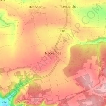
Name: Neckeroda topographic map, elevation, terrain.
Average elevation: 1,467 ft
Minimum elevation: 1,083 ft
Maximum elevation: 1,660 ft
Make a donation
Gear up for your next adventure:
As an Amazon Associate, this site earns from qualifying purchases at no extra cost to you.